Global Net FX - Layer Manager
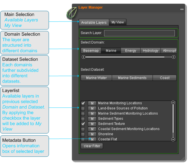
The Layer Manager is one of the most complex tool. It can be understood as a highly configurable TOC. Two separate presentations enable the user to display all available layers, select layers he is interested in and combine them to a set he will be working on afterwards.
The first presentation will be referred to as Available Layers. It lists all layers that are available to the currently logged in user. The layers are categorized into so-called datasets (group layers) and domains.
The first and most important step to perform analysis or views is the selection of layers. To find the best appropriate and available layer for your map the layers are categorized into domains and datasets. For each layer you can show metadata information. In addition you can search metadata for name or text in description.
In detail
A domain could be: basemap, marine, energy, hydrology, atmospheric, Industrial. The available layers within the domains are depending on the rights of the useraccount. Usually the layers are shown in white font. When a layer appears in yellow color it means that this layer have had a problem to load. If you add such a layer to map, the system tries to load the layer again. If the yellow color is persistent, the layer is not available at present.
My View
The second presentation is named MyView. In the MyView perspective the user has his own choosen subset of layers. He can setting transparency or visibility on single layers and arrange the layers in the map. For each layer, legend symbols and metadata are provided. Furthermore, MyView is the place to determine which layers are selectable and editable by other tools. MyView represents the control- and information center for the added layers. The user is able to select setting for the map layout, get additional information and indicates presets for following processes.


