GISCON geo.engineering.gmbh

Our competence center in Brunswick offers specialized services in the fields of environment, forestry, nature conservation, ecology and geology. We offer a wide range of expertise in geospatial processing, development and web provisioning of different kinds of applications.
A success story
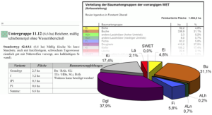
ATES (Automatic creation of description for foresst location-types) is not a single program, but a product family consisting of different hardware and software components. ATES provides forest enterprises with concrete, decision-relevant site-specific information. In addition, ATES automatically excerpts the desired site-specific information from various extensive data sources, structures it according to the user's specifications and prepares it statistically.
The optimal management of forest areas is fundamentally based on the results of local site mapping. For planning and management measures, this information must be collected extensively from analogous sources. A process that is very time-consuming and does not result in uniform results.

ATES is a modularly structured product and service group for the automatic creation of foresst location-types in the context of site mapping for Lower Saxony and Schleswig-Holstein.
Summary of our fields of Application:
- Systems and requirements analysis
Consulting, needs assessment and implementation of Geographic Information Systems (GIS)
Implementation of common Web-based GIS technologies
Spatial data modeling and integration
Development ArcGis Plattform - Digital cartography
User-oriented extensions, Addins, interfaces and application deployment
Applications development and systems integration
Development, modeling and maintenance of Geo-databases and other information systems
Crisis management, project rescue, restructuring and optimization of existing GIS systems
