DisAgg - Spatial Disaggregation of Zonal Data for ArcGIS®
 Spatial analyses in the fields of urban and regional planning, transport planning, environment, climate or geology often require high resolution socio-economic data. Such analyses work with raster data to calculate indicators such as exposure to air pollutants or to noise.
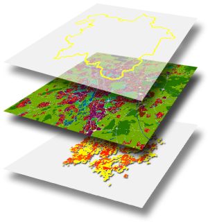
In many cases available socio-economic data do not have the necessary spatial resolution. Usually, data on population, employment or housing are available only for larger areas such as provinces, districts, municipalities or other statistical entities, i.e. units that might be too coarse to be used in such spatial models.
This is where DisAgg extension for ArcGIS® might be instrumental. Its main function is to spatially disaggregate zonal data to raster level. Unlike other approaches which distribute zonal data equally to raster cells, assuming same density in all parts of a zone, DisAgg takes account of actual land use schemes, assuming that areas of different density within a zone correspond to different land-use categories. Data are then disaggregated by complex Monte-Carlo simulations.
Required input information
- Polygon layer with zone boundaries
- Polygon layer with land-use classes
- Zonal data to be disaggregated (e.g. population, households, employment)
Generated output
- Raster layer with disaggregated zonal data
- Regular point layer with disaggregated zonal data
- Polygon layer with disaggregated zonal data (optional)
Key features
- User-defined raster resolution
- Selection of spatial subsets
- Disaggregation of any zonal data
- Assignment/manipulation of weights
- Pre-defined sets of weights
- Full integration with ModelBuilder and Python
- Batch processing and raster templates
- Preview and log function
- Quality assessment of output
- Automatic generation of reports
- Multilingual user interface: English, Arabic, German
- Accepted formats: ArcSDE®, Personal and File Geodatabase, shapefile, or ArcInfo® coverage
Screenshots of DisAgg
Below you can see some Screenshots of some Interfaces of DisAgg.
Please click on one of them to see them in fullsize and to get additional Information.
 Weights dialog box Weights dialog box |
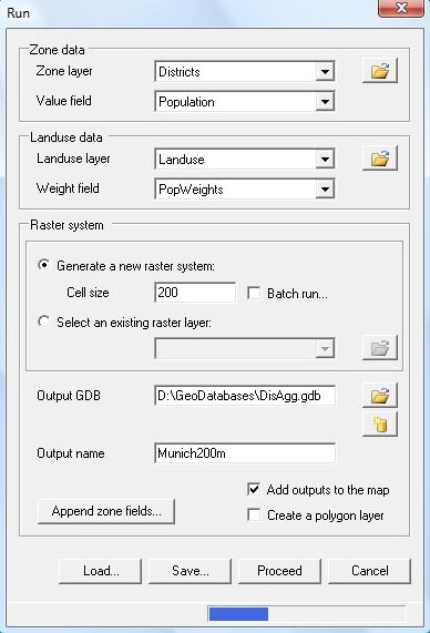 Run dialog box Run dialog box |
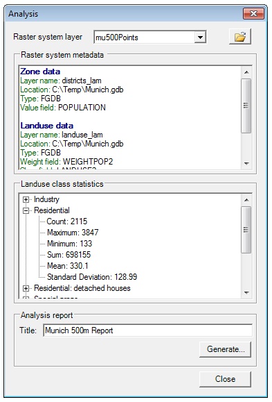 Analysis dialog box Analysis dialog box |
Fields of application
DisAgg can be best applied as a powerful interface linking raster data with small-scale socio-economic data. DisAgg can be integrated within ArcGIS® Model Builder and its scripting capability to build complex spatial models.
Applications may include, but are not limited to:
- Environmental applications
- Risk assessment
- Urban/regional planning
- Transport planning
- Market area research
- Business and marketing
- Fire rescue and ambulance
References
The DisAgg algorithms have been successfully applied in a number of case studies. Examples of application areas in Germany are, the eastern part of the Ruhr Area, the urban regions of Hamburg, Hanover, Munster, Kassel, Stuttgart, Karlsruhe and Munich. Internationally DisAgg was applied in Helsinki (Finland), Inverness (Scotland), Brussels (Belgium), Vicenza and Naples (Italy), Bilbao (Spain) and the State of Kuwait.
System Requirements
- ESRI ArcGIS® Desktop 10.x, or ESRI ArcGIS® Desktop 9.3.1 SP2
- Microsoft .Net® Framework 3.5 SP1
- Microsoft Windows 7®, Windows Vista®, Windows XP® SP3
- Windows XP SP2 is supported only if using ArcGIS® desktop 9.3.1 SP2