Beatona.net – communication of environmental data to the public in Kuwait
About Beatona.net
Key Services and Objectives
Convenience of using Beatona.net
Stakeholders
Opportunities and Constraints
Impact Assessment
The portal shall be a one-stop shop for all environmental data and information in Kuwait. It is expected to play a leading role in raising awareness of the value of the environment among Kuwait citizens and residents. Beatona.net is also a network that offers information about Kuwait's environment from various national, regional and international organizations on one single platform. It also allows the public to participate and interact in the preservation and protection of the environment in Kuwait by reporting environmental phenomena and problems they may encounter to Kuwait EPA in an easy manner, supported by location, descriptive text and photos. The portal is launched since 11 December 2012 on the Internet und can be accessed under www.beatona.net.
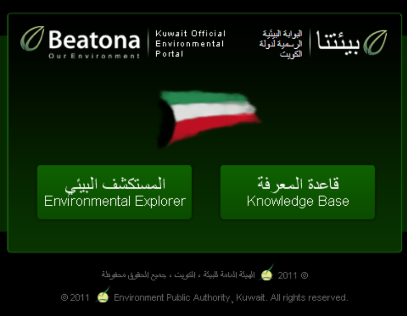 Figure 1: The introductory screen of Beatona.net Figure 1: The introductory screen of Beatona.net |
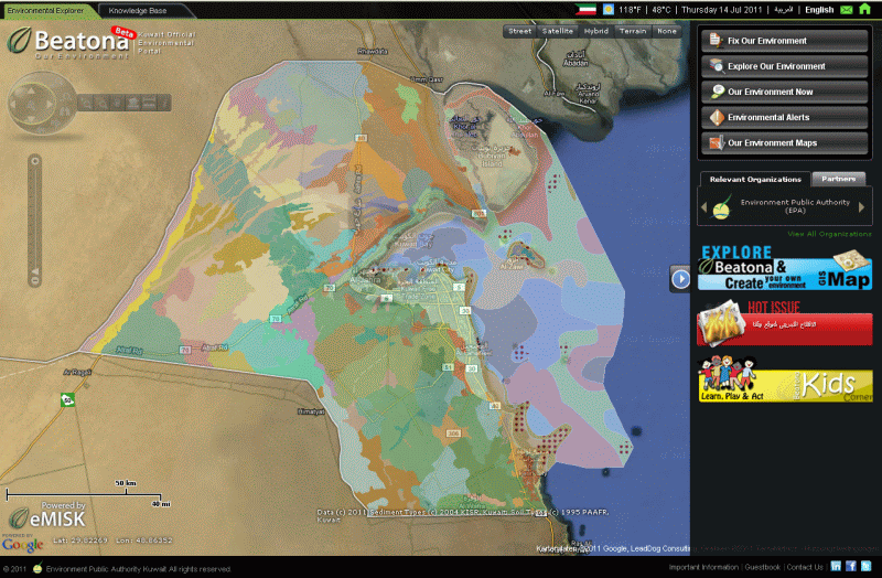
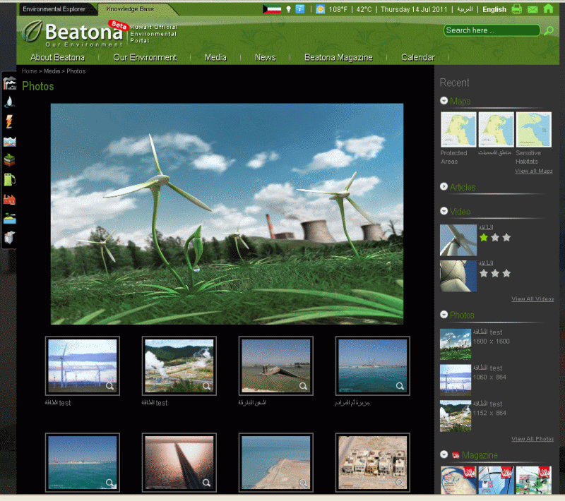
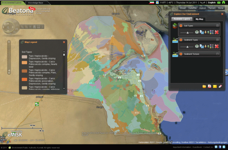
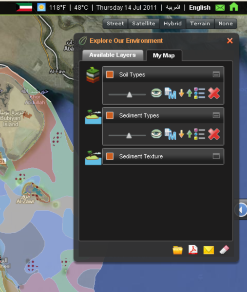
Beatona.net is composed of two major sections: the Environmental Explorer and the Knowledge Base (Figure 1). The Environmental Explorer (Figure 2) is a GIS-based platform that allows the users to project thematic environmental layers on GoogleMaps, which were chosen because they are widely used by the Kuwaiti communities and are regularly updated. This went well in-line with the overall objective of offering simple and self-explanatory tools to the public. The Knowledge Base Section (Figure 3) is a multi-media platform that offers articles, reports, photos, videos, maps and publications about the environment in Kuwait in an impressive manner. |
|
|
Key Services and Objectives
The key services provided by the portal could be summarized as follows:
- Beatona.net is a network of environmental data and information that offers the public information from various governmental organizations and institutions into one platform. This was initiated and supported by the UNEP initiative for the establishment of national environmental information networks (NEIN) in the GCC countries, in preparation for the GCC-wide network. Although Beatona.net is developed and maintained by Kuwait EPA, this was intentionally brought to the background and the portal is rather presented as Kuwait’s official environmental portal, so that all stakeholders and contributors to the portal get the feeling of the ownership.
|
|
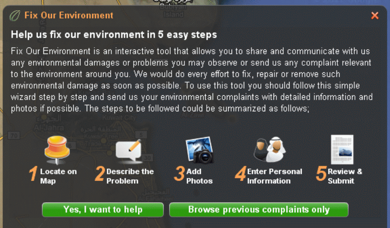 |
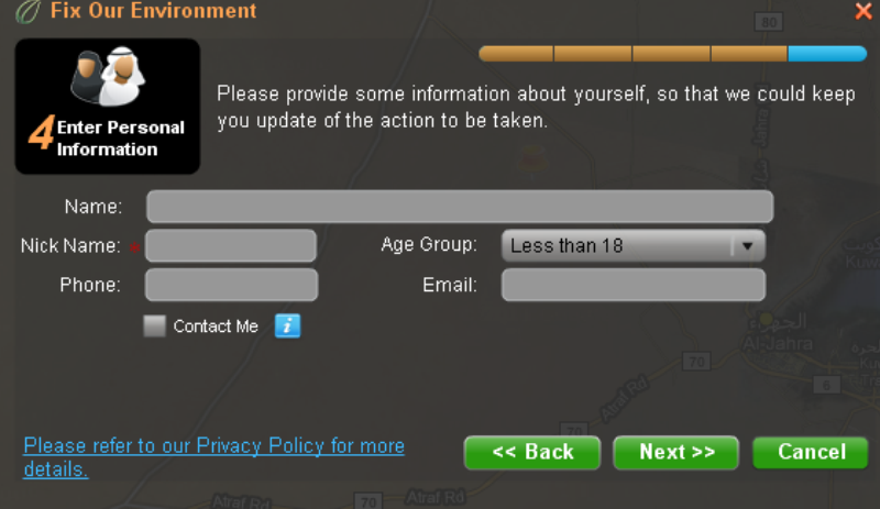
| construction material on the side of the road, a tree about to fell down or something like that. Beatona Administrator would forward the reported problem to the relevant EPA department, or external entities, and follow up on the problem, report back to the portal on the progress until the problem is solved. |
||
|
 |
|
|
 |
|
 |
|
 |
|
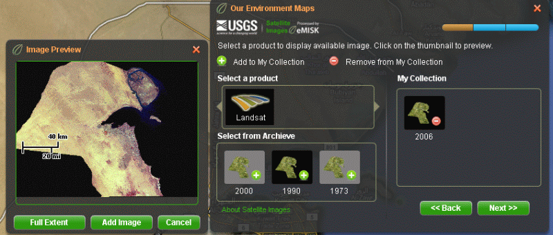
| These includes maps based on Satellite Imagery like a series called Kuwait form Space as well as readily rectified and mosaiced Landsat Imagery for Kuwait under an agreement between Kuwait EPA and USGS. |
||
Convenience of using Beatona.net
Beatona.net visual representations are made in a very simple manner addressing the simple Kuwaiti citizens and residents from all age groups and all education levels. The visualization is based on several aspects that could be highlighted as follows:
- Beatona.net is designed with colorful attractive symbols that appeal to the Kuwaiti citizens and most of the residents in Kuwait.
- It is also available in two languages (Arabic and English) so that it could be easily used and understood by the local population as well as foreign residents and international users from outside Kuwait.
|
 |
|
 |
- Published data layers are selected according to a set of criteria that focuses on the importance to the public. For a layer to be published in Beatona.net, it should be of a certain interest to the public. This has been assessed through intensive research and questionnaires among the public.
|
 |
|
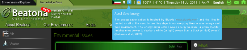
| of the anticipated energy saving of using black color screen in the internet. The user is given the chance to turn the background color into white (turn-light-on function), if this is more comfortable for some users, or to turn back into a black screen by switching off the light. An adequate explanation is given in a small tooltip. |
||
- For more simplicity and in order to ensure popularity among the public, GoogleMaps were used in the background of the portal. It was proven that the users in Kuwait, like most users elsewhere, are familiar with the use of GoogleMaps. Research has also shown that the use of GoogleMaps in the background is preferable by the potential users than for example using local base maps or satellite imagery of Kuwait, which would be soon outdated after publication. Therefore, innovative efforts were done by eMISK team to fully integrate GoogleMaps with ESRI ArcGIS Server engine, upon which the eMISK Geodatabase is built. In addition to its attractive look-and-feel and efficient response time, GoogleMaps are updated very frequently for Kuwait in comparison to other similar technologies.
As Arab countries in general, and GCC countries in particular, have many traditional, cultural and social aspects in common, Beatona.net is an example that could be easily replicated in other Arab and other developing countries, for disseminating and sharing their environmental data and information with the public.
Stakeholders
Although beatona.net is developed and maintained by Kuwait EPA, it acts as a national network for environmental information in the State of Kuwait. It presents contributions from several Kuwaiti government entities as well as regional and international organizations. Kuwait EPA makes its valuable environmental data holdings, in terms of regular monitoring data of air, water, soil and marine quality, available to the public. Among the major partners of the project is the Ministry of Electricity and Water (MEW) that provides a huge amount of current and historical drinking water quality data. The Public Authority for Civil Information (PACI) provided Beatona with current and up-to-date socio-economic data of Kuwait. The Public Authority for Agricultural Affairs & Fish Resources (PAAFR) is the source of the comprehensive soil classification and land cover layers presented in the Environmental Explorer. The Public Authority for Industry (PAI) contributed the vast information of the industrial zones in Kuwait, factories and their activities. Kuwait Foundation for the Advancement of Science (KFAS) is also a major partner and source of various datasets and atlases that were produced earlier and incorporated now into eMISK Geodatabase. Other stakeholders, who contributed to the development of Beatona.net with consultations and advise, are Kuwait University, Kuwait Environment Protection Society, Ministry of Defense and Ministry of Public Works. On the regional level, the Regional Organizations for the Protection of the Marine Environment (ROPME) as well as the Regional Office of the United Nations Environmental Programme in Bahrain (UNEP/ROWA) are major partners of the project. On the international level, Kuwait EPA has reached an agreement with US Geological Survey (USGS) to make its Landsat satellite imagery from various dates for Kuwait available on Beatona.net for download. Google has kindly offered its reputed GoogleMaps for use as the background maps of Beatona free of charge.
Opportunities and Constraints
There are several opportunities that could emerge from the development and publication of Kuwait environmental information via beatona.net. These could be summarized as follows:
- Beatona.net is being considered to join Kuwait eGov Portal (Kuwait Government Online). Once completed, it will be a key component of the Kuwait Government electronic services and portal. This indicates the value of the environment to both the Kuwaiti Government and the public.
- eMISK, the system behind beatona.net, is setting Kuwait vision and policies for the collection, storage, processing and dissemination of environmental information in Kuwait over the next decade. The so-called "Kuwait Geo-Environmental Data Vision 2025" is being developed at Kuwait EPA under eMISK initiative and is known for short as "eMISK Vision 2025". This is seen in Kuwait as the cornerstone for geo-environmental data infrastructure in Kuwait. The anticipated policies and standards are to be used by all organizations working on the environment in Kuwait. An agreement has been reached between Kuwait EPA and ESRI Inc., after which ESRI is to review eMISK standards and models and adopt them as ESRI Environmental Data Models, complementing the various ESRI industry data models. The chances are high that eMISK Vision represents the core for an initiative to develop Kuwait spatial data infrastructure.
- Beatona.net is considered as one of the pioneer programs in the Arab Region that fulfils the UNEP and AGEDI initiatives to establish a set of National Environmental Information Network (NEIN) in the Arab Region and other developing countries in the Middle East. Beatona.net could be replicated in other countries towards the development of a GCC-wide and then an Arab environmental information network.
- As an outlook, Kuwait EPA and eMISK team are anticipating the development of some of Beatona services and modules on mobile phones like iPhone and Android-based smartphones. A plan is there to start with an iPhone App for Fix Our Environment (FOE) to be followed in the future by other further modules.
Despite the above mentioned opportunities, some constraints could also be identified. Some of the major constraints could be summarized as follows:
- Along with the technical changes introduced by beatona.net to the Kuwaiti society in general and to Kuwait EPA in particular, a set of institutional changes are required and are seen as a challenge by the management of Kuwait EPA. A module like Fix Our Environment (FOE), for example, requires a high degree of coordination and cooperation, not only among the different EPA departments, but also among the various organizations and stakeholders in Kuwait. Some complaints and environmental problems reported over FOE are within the mandate of other external entities, like for example; Kuwait Municipality, Ministry of Electricity & Water and Ministry of Public Works. Coordination efforts are now in place in order to ensure an efficient and prompt reaction to the citizen's complaints. Any kind of delay in addressing such complaints, may affect the rate of use and overall confidence in the application.
- All data layers offered by the Explore Our Environment (EOE) module are now collected from the various partners and held centrally in eMISK Geodatabase by Kuwait EPA. A set of agreements were signed between Kuwait EPA and external entities in order to organize the data sharing process. The future plans are to maintain such information by their data custodian and to share them electronically over Beatona.net through Kuwait national information network. The risk is rather there, that partners and stakeholders are not well prepared for such electronic link and therefore affect the overall sustainability of the portal. Discussions are being conducted with Kuwait Central Agency for Information Technology (CAIT) in order to facilitate and support building the adequate nodes at the various stakeholders.
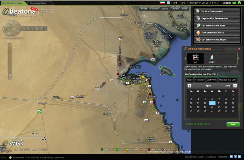
- Another challenge is the publication and dissemination of real-time environmental quality data to the public in a transparent manner as part of Our Environment Status (OES) module, without causing panic among the population. Awareness campaigns are being planned so that air, water and other quality index are well interpreted and understood by the public.
- Continuous operations and maintenance of the portal on the long run depend on several factors. Funding for further maintenance and upgrade of the underlying systems is a major challenge that should be secured from now through contracts and agreements. Most of the current personnel are national Kuwaiti young women and men, who were well trained during the portal development process. The sustainability and continuous training of those personnel is being considered by the management.
Impact Assessment
A preliminary research on the impact of Beatona.net on the community in Kuwait showed that the population is awaiting such a platform, from which they could gain official answers and information to their environmental questions. The direct and indirect benefits of Beatona.net portal were summarized as follows:
- It shall promote Kuwait as an environment-friendly country and allow Kuwait to play a leading role in environmental information sharing and dissemination in the region.
- It shall facilitate data sharing and data exchange among the stakeholders in Kuwait's Government.
- It shall disseminate authorized and authentic environmental information about Kuwait to the public inside and outside Kuwait.
- It shall act as a One-Stop-Shop for authorized environmental information in Kuwait
- It shall raise the awareness of the public of all levels of the values and importance of the environment.
- It shall act as a platform of interaction with the public and encourage public participation by collecting complaints, feedback and suggestions from the public.
- It shall facilitate international coordination and collaboration towards the integrated environmental network of Gulf Cooperation Council (GCC), similar to the Eye on Earth platform of the European Union.