Efficient solutions arise from growing customer relationships

We stand for that!

Latest News

  • 1
  • 2
  • 3
  • 4

GISCON geo.engineering.gmbh


braunschweig profile

Our competence center in Brunswick offers specialized services in the fields of environment, forestry, nature conservation, ecology and geology. We offer a wide range of expertise in geospatial processing, development and web provisioning of different kinds of applications.


A success story

ATES (Automatic creation of description for foresst location-types) is not a single program, but a product family consisting of different hardware and software components. ATES provides forest enterprises with concrete, decision-relevant site-specific information. In addition, ATES automatically excerpts the desired site-specific information from various extensive data sources, structures it according to the user's specifications and prepares it statistically.

The optimal management of forest areas is fundamentally based on the results of local site mapping. For planning and management measures, this information must be collected extensively from analogous sources. A process that is very time-consuming and does not result in uniform results.

ATES Statistik

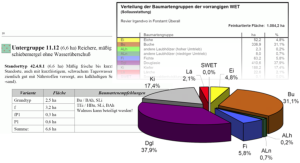
ATES is a modularly structured product and service group for the automatic creation of foresst location-types in the context of site mapping for Lower Saxony and Schleswig-Holstein.


Summary of our fields of Application:

    Systems and requirements analysis
    Consulting, needs assessment and implementation of Geographic Information Systems (GIS)
    Implementation of common Web-based GIS technologies
    Spatial data modeling and integration
    Development ArcGis Plattform - Digital cartography
    User-oriented extensions, Addins, interfaces and application deployment
    Applications development and systems integration
    Development, modeling and maintenance of Geo-databases and other information systems
    Crisis management, project rescue, restructuring and optimization of existing GIS systems
 

why giscon

Independent consultants

GISCON consultants and experts observe and encourage the use of the Open Geospatial Consourtium (OGC) open standards for geospatial content and services, sensor web and Internet of Things, GIS data processing and data sharing.

Proven experience in various industries

GISCON team always includes subject matter experts (SMEs) in the relevant domain of work in addition to the GIS experts. Therefore, we speak the same industry language and fully understand the needs and requirements.

International network of partners and freelancers

GISCON has developed an international network of excellent partners from public institutions, universities, NGOs, freelancer experts and the private sector. Project teams are always composed of the most suitable experts for the problem at hand, regardless if they are GISCON employees or come from one of our partners.

Flexible and diverse supporting models

GISCON offers various levels of engagement with the clients for support with expertise and consultancy services. Depending on the clients' needs, requirements, in-house capabilities and available budget, GISCON has the flexibility to engage, support and be part of the team.

All-around IT Solutions

GISCON provides end-to-end information and communication technology (ICT) solutions and services from one hand. This is extremely important especially in large projects, where GIS is linked to document management systems (DMS), enterprise resource planning (ERP), content management systems (CRM), internet of things (IoT), big data and other relevant systems and technologies.

Continuous research, development and innovations

GISCON believes that the continuous research and development is what enables us to support our clients with efficient and reliable solutions and to remain competitive in a rapidly changing market. Systems, solutions and innovations are tested and applied at our working environment before we implement or even recommend them to our clients.