


Product Portfolio
Our claim is to provide people with decision-relevant information in their daily work and to optimize business processes in context of
- Geopraphical Informationssystems (GIS) and
- Enterprise Resource Planning-Systems.
We are offering a wide range of products for different technologies and branches depending on requirements of the region, environment and varying political frame conditions. Based on the expertise of our specialized competence centres we are able to implement high quality solutions for almost every field of application. These efficient solutions arise from individual customer relationships in countries all over the world.
Take a look on our international product portfolio, separated into branches.
KTS - Process optimisation in the creation of maps
intuitive ● flexible ● efficient

Your requirements:
The main problem when it comes to creating a series of maps using ArcGIS is the manual, and thus time-consuming and error-prone sheet by sheet modification of dynamic map elements. In addition, a lot of programming effort, often even the creation of individual applications, is still needed for the solution of certain cartographic standard requirements with DataDrivenPages (ArcGIS Desktop 10.x).
Our solution: KTS
KTS provides a complete tool box for the continuous process support during the production of a series of high quality maps. KTS gives optimal support to cartography departments in public authorities or businesses in all mapping tasks. Furthermore, the highly efficient tools can be implemented according to demand as they integrate perfectly with ArcGIS as separate add-ins. The result: previously time-consuming work processes are comfortably reduced with just a few clicks of the mouse, your maps are created more quickly, they are produced with less effort and are more effectively administered.
Using the core layout generator and output tool components, as well as a large range of other special tools, KTS carries out the creation of demanding map layouts and the completely automatic export of print files - all without any programming effort! As a fully developed software product, KTS is entirely integrated into the range of functions and interfaces of the ArcGIS desktop. KTS is already available to use with ArcGIS 10.5.
- KTS fills the gaps between freely available solutions like the ‘MapBook’ or ‘DataDrivenPages’ (ArcGIS) and expensive high-end solutions, such as ‘PLTS’.
- All KTS tools can be purchased individually, so you can put together your own optimal tool collection, individually and at a low cost.
- Upon request we create complete workflow concepts, including orientation and the training of your employees.
Established technical basis
- small, self-contained tools (add-ins)
- modular architecture: easy to maintain and expand
- simple, clear graphical user interface
- user friendly configuration data which can be read and edited by the user (XML)
- completely object-oriented (ESRI ArcObjects) using the NET-Framework, carried out with C#
- useable with all ArcGIS licence levels
- flexible licence model
Global Net FX - Reporting Module
The Reporting Module is designed as an aid for user to create reports out of screenshots, tables and charts.
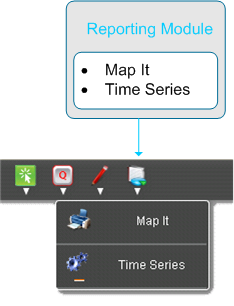
It consists of two parts:
- Map it controls the screenshot output for current map selection, including the option to print legends also.
- Time Series manage the query and visualization for the time series data. The expected results will be available as charts or table. To use the result for presentation and further research it is possible to print the result as graphic or export the data as csv-file in order to use the data in Microsoft Excel or other spreadsheet software.
Map it
Map it create a pdf with the map in the given extent and with all visible layers in a predefined layout. If required, it is possible to add the legend to the layout.

Time Series
Time Series contains three available predefined queries with different variations to query TimeSeries-tables. The results are shown as charts and table. To use the results for presentation and further research it is possible to export charts as graphic and tables as csv-file.
