Our software development follows a standardized multi-step process. In the analysis phase, we work with our customer to define both the system and user requirements. Subsequently the functions and software modules are graphically modeled using the unified modeling language (UML) and the interfaces are developed taking software ergonomic aspects into consideration. Due to immediate feedback with the customer we meet all requirements in an optimal way and can
Standards
In order to guarantee the quality of our work in the long run we place great value on the improvement of all business processes and comprehensive quality management. Part of this is, along with process definition and information storage in professional documentation systems, the project management following the German Standards adapted V-model XT and the software development in compliance with international standards.
The application of the most modern technologies of well-known brands and partnerships with market-leading GIS and IT corporations (e.g. ESRI, ORACLE and Microsoft) provide the basis for our state-of-the-art solutions. We continually integrate up-to-date know-how by cooperating with institutes and service providers of neighboring fields of expertise.
Development platforms
We support all common platforms in software development in the classic desktop area as well as server area.
In the desktop area we are mainly referring to the operating systems Windows XP and Windows7.
The use of Windows Terminal Server®/ Citrix-Metaframe is supported in enterprise systems.
In addition, we are currently developing applications for Windows Server, Solaris® and diverse Linux-Derivates in the server area.
In the mobile area, we develop applications for smart phones and handheld devices based on Microsoft Windows Mobile, iOS and Android operating systems.
IT Competences
Alongside the classic ArcGIS Desktop extensions based on ArcObjects, our solutions often exceed the narrow GIS area. They expand over different areas of the modern IT landscape.
ArcGIS Server web-based client-server-solutions allow for the use of central data and typical GIS functions as services via browser. As an integrated portal solution they allow for the visualization and analysis of geodata, the editing of geometries and attributes as well as the effective management of applications, users and access rights. In this process, all of the requirements of a modern Spatial Data Infrastructure (SDI) are taken into consideration, such as SOA (Service-Oriented Architecture) and approved internet standards (e.g. from the OGC).
Our effective administration systems provide an integrated operation, communication and company management solutions. As they have an independent connection to Relational Database Management Systems (RDBMS) they also allow multi-users interaction.
Apart from desktop and server-based systems we offer solutions for mobile components (PDA / handheld) with well-engineered check-in/check-out mechanisms and GPS link.
Interfaces for data conversion and transfer among several commercial products and formats have been one of our key competences in our product portfolio. As one of ESRI's development partners we offer the development, sale and support of bi-directional format converters for the transfer of data to and from ESRI family of products.
Development plattforms
We support all common platforms in software development in the classic desktop area as well as server area.
In the desktop area we are mainly referring to the Microsoft operating systems.
The use of Windows Terminal Server®/ Citrix-Metaframe is supported in enterprise systems.
In addition, we are currently developing applications for Windows Server, Solaris® and diverse Linux-Derivates in the server area.
In the mobile area, we develop applications for smart phones and handheld devices based on Microsoft Windows Mobile, iOS and Android operating systems.
System integration
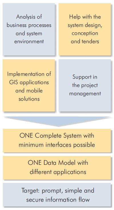
Our many years of experience have shown how important it is to ensure that the existing workflow and IT structures are considered appropriately with each new release of a GIS or application. The demands on a GIS from different departments often result in the co-existence of diverse applications. In an extreme case, each of these isolated solutions has its own requirements regarding data storage, processing and maintenance, meaning each data transfer between the departments inevitably causes additional expenses of time and costs.
The release of a geographic information system as well as the improvement of such isolated solutions requires a comprehensive understanding of existing special fields' applications, related work flows and business processes. The consultants in our competence teams create solutions for the integration of new GIS concepts and technologies into existing IT infrastructures using specific knowledge from the areas of system design and system integration quickly and safely. The results are more efficient work flows and hence a real added value without any extra cost.
GISCON consultants and experts observe and encourage the use of the Open Geospatial Consourtium (OGC) open standards for geospatial content and services, sensor web and Internet of Things, GIS data processing and data sharing.
Proven experience in various industries
GISCON team always includes subject matter experts (SMEs) in the relevant domain of work in addition to the GIS experts. Therefore, we speak the same industry language and fully understand the needs and requirements.
International network of partners and freelancers
GISCON has developed an international network of excellent partners from public institutions, universities, NGOs, freelancer experts and the private sector. Project teams are always composed of the most suitable experts for the problem at hand, regardless if they are GISCON employees or come from one of our partners.
Flexible and diverse supporting models
GISCON offers various levels of engagement with the clients for support with expertise and consultancy services. Depending on the clients' needs, requirements, in-house capabilities and available budget, GISCON has the flexibility to engage, support and be part of the team.
All-around IT Solutions
GISCON provides end-to-end information and communication technology (ICT) solutions and services from one hand. This is extremely important especially in large projects, where GIS is linked to document management systems (DMS), enterprise resource planning (ERP), content management systems (CRM), internet of things (IoT), big data and other relevant systems and technologies.
Continuous research, development and innovations
GISCON believes that the continuous research and development is what enables us to support our clients with efficient and reliable solutions and to remain competitive in a rapidly changing market. Systems, solutions and innovations are tested and applied at our working environment before we implement or even recommend them to our clients.
We use cookies
We use cookies on our website. Some of them are essential for the operation of the site, while others help us to improve this site and the user experience (tracking cookies). You can decide for yourself whether you want to allow cookies or not. Please note that if you reject them, you may not be able to use all the functionalities of the site.